Main Menu

You are here

Miscellaneous Projects

North Yorkshire Polyhalite Project

Client
Service Performed
Dr. Sauer & Partners provided commercial support, SCL design verification and functioned as a mediator between Sirius Minerals’ mining and construction team.
Commencement - Services
April 01, 2019
Completion - Services
October 31, 2019
Location
Whitby
Yorkshire
YO11 3ZB
United Kingdom
Geology description

Most of the MTS is developed within the Redcar Mudstone Formation. It comprises alternating layers of silty mudstone and clayey siltstones with subordinated thin beds of limestone and sandstone.

Bands of ironstone nodules and fossil shells as well as pyrite are present in places. Multiple major fault systems were identified that cut the MTS alignment. 

Geology types
Description

North Yorkshire holds one of the largest, high grade polyhalite reserves worldwide. It is located within the North York Moors National Park, ca. 1800m below surface. Once processed, this mineral functions as an organic fertilizer to boost harvest. Sirius Minerals plc are currently developing the infrastructure to mine the polyhalite. This operation requires deep shafts to access the mineral body but also demands an extensive mass transport system (MTS) to keep the impact on the National Park to a minimum. Therefore, at ca. 350m below surface, a series of SCL tunnels link the deep shafts to a conveyor belt system, which again connects the mining operation via a 37km TBM tunnel to its material handling facility.

Activity
Categories
Miscellaneous Projects, Mine, Shaft
Construction methods
Tunnel length
37km
Project overview
Woodsmith mine site close to Whitby
Project number
515C
Final cost
£4.2 billion GBP

Leesburg Inter-Quarry Tunnel - Execution

Service Performed
Site supervision on behalf of Luck Stone Corporation including supervision of all SEM activities, quality assurance services, cost and schedule control and design coordination on site.
Commencement - Services
April 01, 2018
Completion - Services
March 01, 2019
Location
Leesburg Plant
20210 Luck Lane
Ashburn, Virginia, VA 20147
United States
Geology description

Located within the Culpeper Basin, a sedimentary rock formation characterized to be of Lower Mesozoic Age. The existing Luck Stone quarry is situated in a Diabase intrusion (dyke) of this sedimentary rock.

Geology types
Description

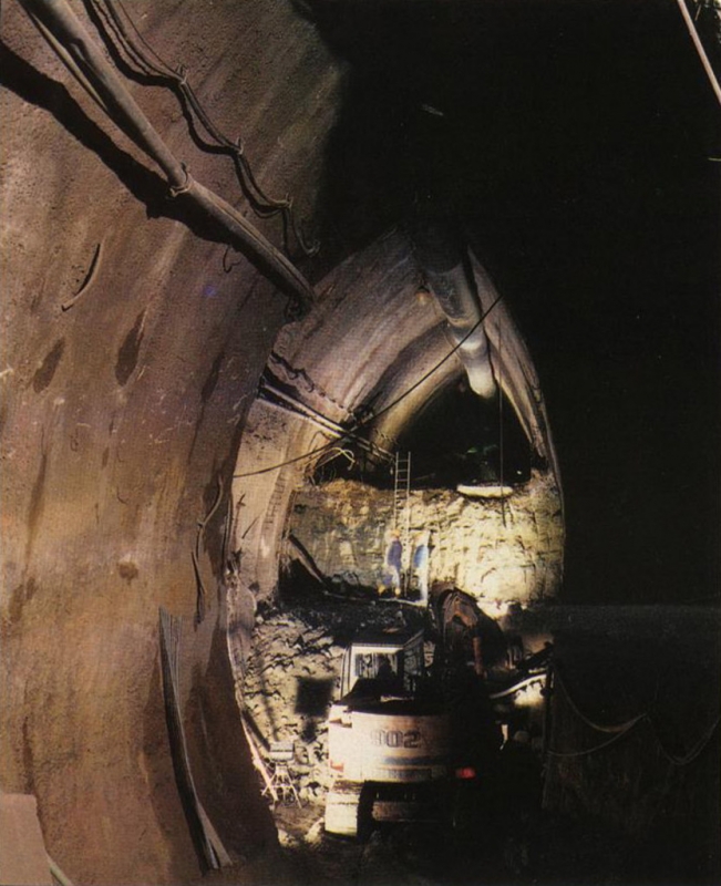
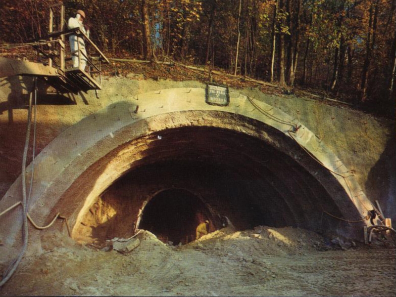
Luck Stone Corporation (LSC) is the nation's largest family owned and operated producer of crushed stone, sand and gravel. At their plant in Leesburg, Virginia, Luck Stone Corporation acquired a new quarry, which is located to the West of Goose Creek river. An inter-quarry tunnel was constructed to link the existing South-Eastern pit with the new West pit. The tunnel's cross section is approximately 45 feet in diameter, and the tunnel's length is approximately 1275 feet. The tunnel crosses the Goose Creek river approximately 50 feet beneath. The excavation method was drill and blast in hard rock (diabase).

Activity
Categories
Miscellaneous Projects, Mine
Special Construction techniques
Tunneling under
Tunnel length
1275 feet
South-East portal - final stage
South-East portal - construction stage
Project number
242E
Final cost
$13 million USD

Leesburg Inter-Quarry Tunnel - Design

Service Performed
Conceptual design with various tunnel options. Final tunnel design consisting of drawings, specifications, and calculations. Client support during bid phase.
Commencement - Services
January 01, 2017
Completion - Services
April 01, 2018
Location
Leesburg Plant
20210 Luck Lane
Ashburn, Virginia, VA 20147
United States
Geology description

Located within the Culpeper Basin, a sedimentary rock formation characterized to be of Lower Mesozoic Age. The existing Luck Stone quarry is situated in a Diabase intrusion (dyke) of this sedimentary rock.

Geology types
Description

Luck Stone Corporation (LSC) planned to open a new quarry on the Western side of Goose Creek river, a component of the Virginia Scenic Rivers System. A tunnel was envisioned to connect the new Western quarry with the existing South-Eastern one below the river. The rock cover between the tunnel and the river was approximately 50 feet. The tunnel is 1275 feet long with a diameter of 45 feet. It is designed to accommodate large scale mining trucks as well as a conveyor belt for material transport which is scheduled to be installed in the future.

Activity
Categories
Miscellaneous Projects, Mine
Construction methods
Special Construction techniques
Tunneling under
South-East portal excavation sequence
South-East portal excavation
Vertical bench drilling
Project number
242D
Final cost
$13 million USD

Luck Stone Fairfax Plant – Inspection Works

Service Performed
In-depth inspection of a connector tunnel in accordance with TOMIE manual and the SNTI manual of the U.S. Department of Transportation - FHWA.
Commencement - Services
July 01, 2016
Completion - Services
July 31, 2016
Location
15717 Lee Hwy
Centreville, VA, VA 20121
United States
Geology description

The prevalent rock type of the tunnel is diabase. The rock mass is moderately jointed, with closely to very closely spaced joints. The rock is slightly weathered.

Geology types
Description

Inspected tunnel connects two quarries at the Luck Stone Corporation Fairfax plant. The tunnel crosses beneath the Lee Highway (US Route 29), in a North-South direction. Built ca. 1975, the tunnel is partially unlined and in rock; approx. 190 feet long and approx. 22 feet wide and 22 feet high. As the Northern quarry side is already exhausted, the tunnel is rarely used with just one or two transits per day.
Dr. Sauer & Partners performed an in-depth inspection of a connector tunnel; assessed the tunnel condition and provided remedial measures.

Activity
Categories
Miscellaneous Projects, Mine, Tunnel Rehabilitation
Service areas
Construction methods
Tunneling under
Connector Tunnel - North Portal / Highwall
Connector Tunnel - South Portal / Highwall
Project number
242E1
Final cost
n/a

Los Bronces Mine

Service Performed
Dr. Sauer & Partners provided conceptual design and basic engineering.
Commencement - Services
August 01, 2009
Completion - Services
November 01, 2011
Location
Los Andes
Valparaíso
Chile
Geology description

The geological setting is dominated by the volcanic activities of the region and includes magmatic rocks such as monzonite, andesite, and dacite.

Geology types
Description

Los Bronces copper mine, an open-pit operation at an altitude of 3500m ASL in the Chilean Andes, planned to utilise a tunnel for further deposit exploration and development. The project consisted of an 8.2km tunnel link between Los Bronces and Confluencia, connecting two processing plants. By applying drill and blast methods, a chamber was prepared to launch a 4.5m diameter tunnel boring machine which took over further excavation. A difficult geological and hydrological setting, extreme weather conditions as well as the high altitude and the rough terrain, provided a challenging environment.

Activity
Categories
Miscellaneous Projects
Final cost
$6,000,000
Construction methods
TBM Tunel Sur (http://www.construccionminera.cl)
Tunnel excavation with TBM
Project number
432C
Final cost
$6 million USD

Kaverne Landsberg

Commencement - Services
December 01, 1987
Completion - Services
January 01, 1991
Location
Landsberg am Lech, Bavaria
Germany
Technical data

Underground parking cavern: constructed in soft ground using NATM excavaton, 180 m long with a 240 m² approx. Cross section (18.9 m wide by 16.4 m high).

Geology description

Water bearing gravels, dry tertiary clay, arl, silt and sand

Description

Shallow underground parking cavern for some 350 cars: constructed in soft ground using NATM excavation 180 m long with a 240m² approx. Cross section (18.9 m wide by 16.4 m high)

Categories
Miscellaneous Projects
Graphics, Parking Cavern Layout
Excavation of center part

Barrow-upon-Soar Tunnels

Service Performed
Value engineering: NATM detailed design, FEM calculation and design of waterproofing system.
Commencement - Services
March 27, 1986
Completion - Services
December 27, 1988
Location
Barrow upon Soar
Leicestershire
LE12 8GB
United Kingdom
Technical data

2 inclined transportation tunnels, length of 505 m (1656 ft) each. Under hydrostatic waterpressure, up to 55 psi for the first 300 m (984 ft) of each drift.

Geology description

River and glacial deposits, Blue Lias, limestones, Rhaetic Mudstones, Tea Green Marl, Mercia Mudstone, Tutbury Gypsum.

Geology types
Description

British Gypsum's operation at Leicestershire, a plaster production plant, improved infrastructure by establishing 2 new tunnels on site. Ground treatment for the control of water ingress during construction, drift excavation, final lining and a water ingress guarantee had to be taken into consideration. By applying NATM, the tunnel was excavated by roadheader and supported with lattice girders followed by shotcrete. The construction met the final water ingress guarantee by installing a PVC waterproofing membrane between the primary shotcrete lining and the final unreinforced in-situ concrete lining which is of a watertight quality in the invert.

Activity
Categories
Miscellaneous Projects
Final cost
$4,000,000
Typical cross section
Canopy construction at portal
Project number
117D
Final cost
£4 million GBP

Water supply EIDAP

Client
Service Performed
Feasibility Study
Estimated cost
$15,700,000
Commencement - Services
December 01, 1995
Completion - Services
January 01, 1996
Location
Athens
Greece
Technical data

Tunnel Length: 1.7 km Section: 12 m3 Proposed 1.7 km NATM tunnel with in-situ concrete lining as part of 20km surface pipe line water supply scheme.

Geology description

Flysh, sandstone siltstone

Categories
Miscellaneous Projects
Service areas

Inter-Quarry Tunnel

Service Performed
Design and On-Site inspection services
Commencement - Services
March 29, 1994
Completion - Services
December 29, 1994
Location
Leesburg, VA
United States
Technical data

Haulage tunnel with approx. 80 ft (24 m) of overburden to connect new and old quarries separated by a VA Park Authority trail. Applying NATM principles, the tunnel was mined using drill and blast, lined with steel fiber reinforced shotcrete. Length: 285 ft (87 m), Width/Height: 34 ft (10 m)/27 ft (8 m), Section: 814 sqft (76 m²), Excavation Method: Drill and Blast.

Geology description

Relatively competent rock mass with diorite as the base rock allowing 10 ft ( 3 m) rounds for the top heading and bench excavation. Due to previous blasting the rock at the Portals was severely fractured.

Categories
Miscellaneous Projects
Final cost
$600,000
Portal of completed tunnel
Portal Image from the Luck Stone Project - 90% completion level
View of Tunnel Location
Regular Cross Section
Shotcrete Canopy at the South Portal

Pocoima Dam Spilway Reconstruction

Service Performed
Tunnel final lining alternative proposal
Commencement - Services
January 29, 2001
Completion - Services
October 21, 2005
Location
Los Angeles, CA
United States
Technical data

Tunnel widening from a 14 ft (4.3 m) to 29 ft (8.8 m) springline diameter section.

Geology description

Hard Rock

Geology types
Categories
Miscellaneous Projects
Pacoima Dam
Cross Section of Spilway Tunnel